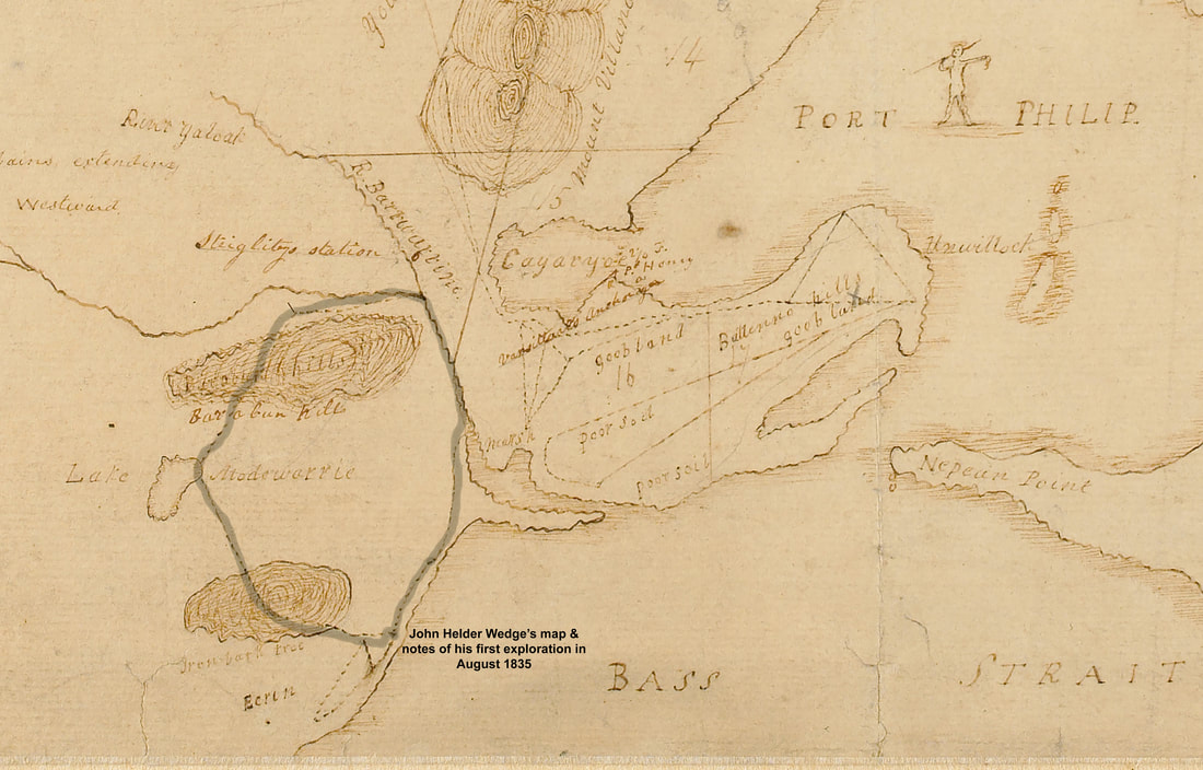
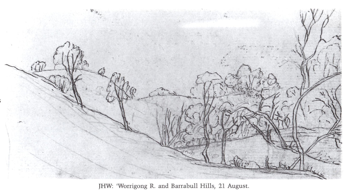
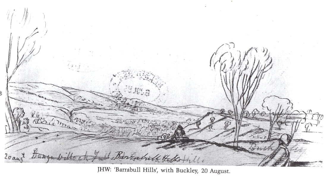
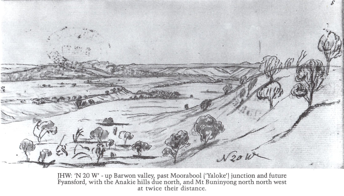
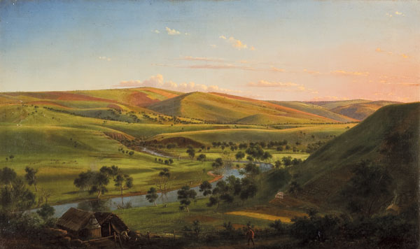
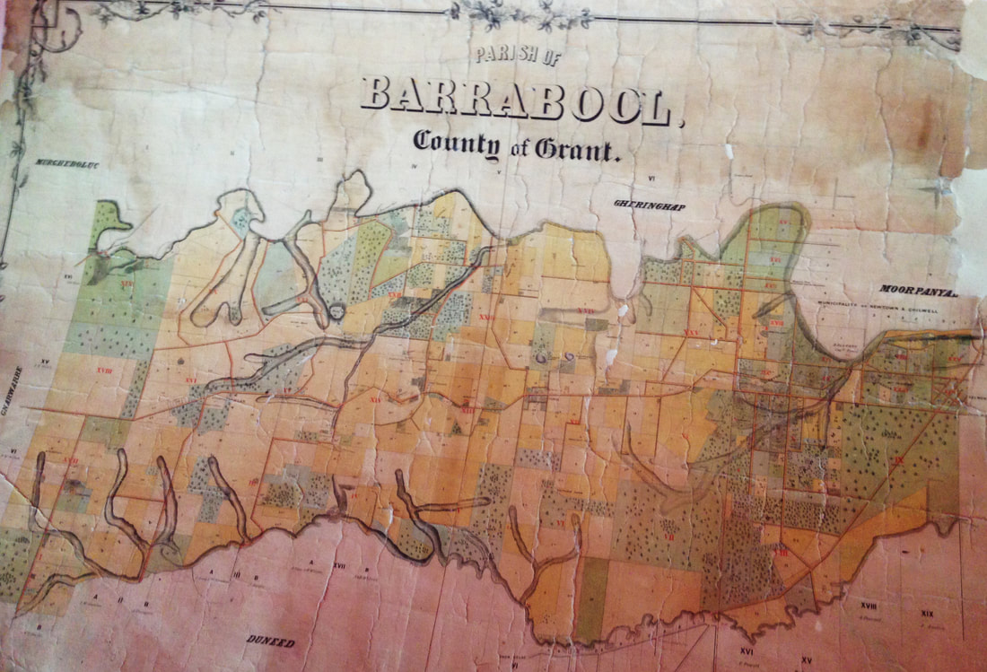
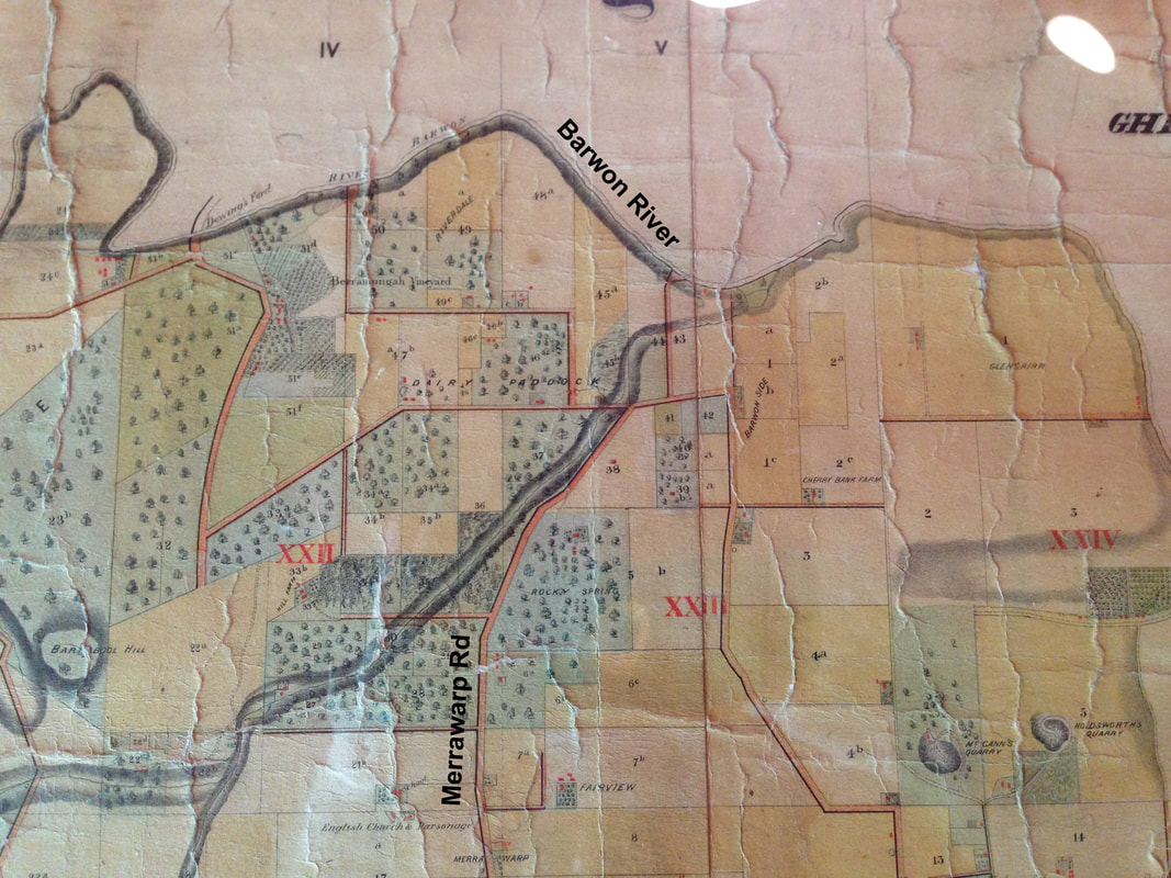
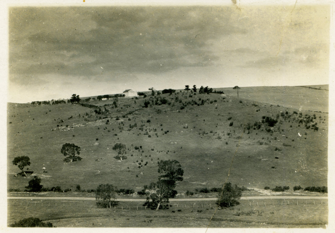
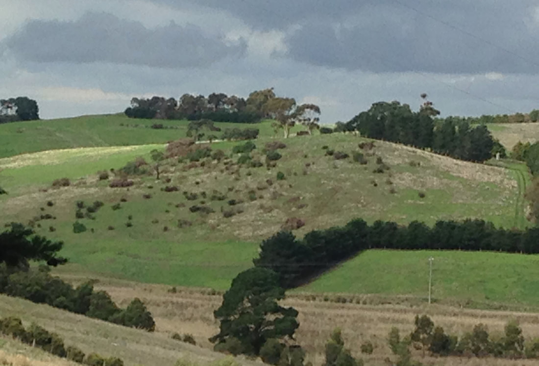
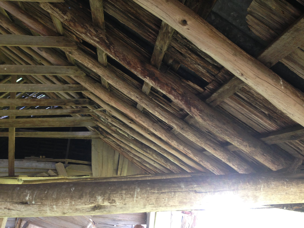
 The seven day treck of Wedge and Buckley marked on Wedge's original map of the Geelong Region The seven day treck of Wedge and Buckley marked on Wedge's original map of the Geelong Region 1835 – Walking the Hills with Wedge and Buckley On Tuesday 18th August 1835, the first steps were taken toward the colonisation of Geelong by John Helder Wedge, a surveyor working for the Port Phillip Association. After setting up camp at Indented Head, Wedge guided by William Buckley who had lived with the Mon:mart clan of the Wadawurrung people for 30 years and knew the area well by its indigenous names, headed into the unknown for a seven day tour. Making observations they walked from Breamlea to Lake Connewarre, followed the Barwon River to Pollocksford, trekked south-east across the Barrabool Hills to Lake Modewarre, headed south-west to Paraparap and then returned back to Breamlea through Jan Juc, a total distance of 70 kilometers. Wedge’s notes provide the first insights into the vegetation of the Barrabool Hills before the pressures of British colonisation began rapid and fundamental vegetation changes. On Thursday 20th August Wedge recorded; “Crossed the Barrabull Hills….for the first 3 miles are of the same description, grass rather light and thinly wooded with sheoak. The soil from thence to the declivity (downward slope) which leads down to the Lake (Modewarre) is a rich brown loam with excellent grass. The soil from the declivity is not so good and rather wet at this time of the year and the grass sour. The country around the Lake is lightly timbered and grassy with very gentle rises and flats” The following day he described vegetation near the lake as “thickly timbered, the gum trees prevailing”. The images below are from wedges diary courtesy of the State Library Victoria. Hover over the image to read the title and click to view in more detail. Wedge’s brief description of the vegetation of the Barrabool Hills is clearly inadequate though we can read that he did distinguish between sheoaks and gums. As a surveyor he was more interested in the economic potential of this new land. His priorities were likely to record the topography, the availability of fresh water, the suitability of the soil for crops and the quality of grass for grazing. This was his first trip from Van Diemen’s Land (Tasmania) and his knowledge of the local plants would have been insufficient to provide detailed plant lists and most of the plants he saw were yet to be named. We know from present day evidence of plant surveys of the Barrabool Hills that there are at least thirteen tree and shrub species surviving on roadsides and private property. Also the grasslands would have been rich with many species of native grasses and flowering herbs because over sixty can still be found today. What can the Colonial artists tell us? In Wedges defense, open woodlands of Drooping Sheoak were a feature of the Geelong district and other parts of south eastern Victoria. Respected artist Eugene von Guerard sketched the harvesting of Drooping Sheoaks for firewood on the Barwon River near Geelong. He also recorded them scattered on a hillside near Keilor, Victoria in a similar density to their likely occurrence in the Barrabool Hills in 1835. A prominent artist at that time, Charles Norton painted a scene in 1846 from Ceres looking back toward Fyansford. He clearly shows an open woodland of Drooping Sheoaks in the foreground, eucalypts along the Barwon River and eucalypt woodlands just north of the river separated by a wide band of open grassland. Artist John Skinner Prout depicted the same scene viewed from a closer location to the Barwon River one year later in 1847, adding credibility to the accuracy of Charles Norton’s earlier painting. Norton also painted Geelong in 1842 and clearly shows Drooping Sheoaks along Moorabool Street with the You Yangs in the background. Barro:aabil Another fascinating insight was provided by Jennifer Dearnaley, a PhD student of plants traditionally used by the Wadawurrung people with reference to Lou Lane's investigations. Jennifer explained that the Wadawurrung name for the Barrabool Hills is barro:aabil which literally translated means ‘the place of the rounded hills’. In an email she explained that their name for the hills describes its morphology which could only be appreciated if the hills had been relatively de-nuded with a low density of trees and shrubs. 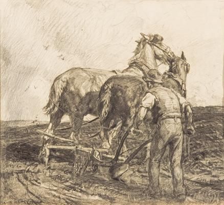 'Turning the plough' Hans Heysen 1920. Courtesy Art Gallery South Australia 'Turning the plough' Hans Heysen 1920. Courtesy Art Gallery South Australia Colonial farmers This scarcity of trees is also supported by the first settlers that lived in the Barrabool Hills. In the 1840’s a farmer described the soil and the openness of the hills; ‘The soil on these hills is exceedingly rich, surpassing it is said any other part of the colony; and unlike most hills and mountains in this primitive region, they are clear of trees. The farmer having nothing more to do than drive the plough into the virgin soil, without clearing or any other preparation’. There were areas where the vegetation was much denser in the Hills. The following extract from an 1851 auction notice for 2849 acres of land located in the Barrabool Hills, 9 miles from Geelong with Barwon River frontage, describes both open country and densely timbered country nearby. ‘The land is of the best description in the district of Port Phillip, subdivided in to farms of 15 – 88 acres each, with easy access to water and among them are many most eligible sites for vineyards and market gardens.…..and there is within one mile of the property an unlimited supply of timber on Government land’. 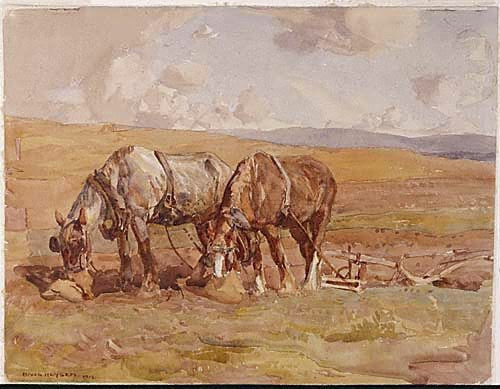 'Polly and Jack'. Hans Heysen, 1919. Courtesy of Art Gallery NSW. 'Polly and Jack'. Hans Heysen, 1919. Courtesy of Art Gallery NSW. Another farmer in the 1840’s remarked on the problem of tree stumps breaking his ploughs; ‘… as long as the land was ploughed it would grow a good crop because the virgin soil was so rich. A blacksmith was kept on the station to repair just the ploughs alone, the ground being full of stumps’. Again in the 1850’s a firm of three brothers leased a farm in the Barrabool Hills. The youngest remembers grubbing 20 – 24 stumps per hectare. ‘... our first farm was 111 acres which had been lightly timbered country, the timber having been felled and carted or burned off. The stumps had however not been grubbed, although the previous tenant had been cultivating the land for seven years before it fell into our hands. Our first operation was grubbing of between 1100 and 1200 stumps’. The McWilliams map In 1861 Andrew McWilliams, an engineer for the Barrabool and Indented Heads Road Districts, published a beautiful and detailed map of the ‘Parish of Barrabool – County of Grant’. His map shows a patchwork of cropping and grazing properties in parched yellow covering approximately 66% of the Hills. The remaining areas shown in pale green are remnant vegetation and the original plantings of vineyards & orchards along the Barwon River. In 1861 these horticulture enterprises accounted for less than 1% of the green areas, therefore McWilliam's map indicates that at this time approximately 33% of the Hills still had native tree cover. In tantalizing detail McWilliams has drawn scattered trees on the pale green areas in an attempt to indicate tree densities. He also varies the shape and size of the trees to depict different tree species. For example Rocky Spring, a property on Merrawarp Rd that is still there today, is shown on his map as a 30ha property with 50 scattered remnant trees and some buildings in red (click on the far right map below to see the detail). This is a density of 1.7 trees/ha which is about average for the densities of remnant vegetation shown on his map. We can assume that McWilliams only included the large trees because if they were drawn to scale I estimate their canopies to be 15 – 30 meters wide. Smaller trees and shrubs were not shown because of the limitations of the map's scale. The McWilliams map of the Shire of Barrabool is available for viewing at the Geelong Library Heritage Centre. Click on the images below to see them in more detail. Putting together the pieces of the puzzle In August 1835 John Helder Wedge and William Buckley would have walked onto a sunny grassy open landscape when they left the shade of the River Red Gums along the Barwon River. Drooping sheoaks, taller species of acacia and a few scattered Manna Gums were likely widely spaced at 30 – 100 meters on the higher and dryer parts of the Hills. Under these taller trees would have been clumps and scattered shrubs like Sweet Bursaria and Tree Violet that are still found in the Hills today. Other types of tall trees that were likely to have been present in this mix are Silver Banksia, White Cypress-pine, Black Sheoak and Cherry Ballart. Some of these elevated open areas would have had no trees or shrubs, being pure grasslands, perfect for the wooden ploughs of the first settlers. In the moister gullies the vegetation was likely denser where widely spaced mature eucalypts dominated, offering the new settlers a good source of building materials and firewood. Even the smaller shrubs in these gullies were significantly larger than they are today. So large that they could be cut for poles for the construction of small outbuildings. An example of this is a buggy shed that was built in the 1850’s with Woolly Teatree poles. This structure is still standing on a property on Honeys Road and the Teatree poles are in good condition. A sample of bark taken from the poles matches bark removed from a present day Woolly Teatree confirming the story passed down through the generations. The original Woolly Teatrees growing in the nearby gully must have been hundreds of years old to have grown to this remarkable size. The rich soils of the Barrabool Hills could have supported a diversity of trees, shrubs and grassland plants at much higher densities than was recorded in the early years of settlement. However evidence suggests that in 1835 it was an open landscape with widely spaced trees and shrubs over rich and diverse grasslands. This was no accident or freak of nature but a description of a designed and highly managed landscape.
Research into the vegetaton of the Barrabool Hills was initiated as part of a Barrabool Hills Landcare Group project. The historic research was supported by the Wettenhall Environment Trust. In my next blog I’ll look at the plant species that are indigenous to the Barrabool Hills and explore why and how this landscape was created by the Barrabool tribe of the Wadawurrung people. Click to read 'The Vegetation of the Barrabool Hills part 4. Plant species - Drooping Sheoaks adorned the hills'
4 Comments
Taylor Gundry
28/5/2021 07:53:10 pm
Great blog Stephen. Thank you for your efforts. My family live in Wandana Hights, I will have to get them to read this.
Steve
29/5/2021 11:43:10 am
Thanks Taylor,
Gidja Lee Walker
31/5/2022 10:50:18 am
Hi Steve, great collation of info
Steve
31/5/2022 12:11:54 pm
Hi Gidja, Leave a Reply. |
Click on the image below to discover 'Recreating the Country' the book.

Stephen Murphy is an author, an ecologist and a nurseryman. He has been a designer of natural landscapes for over 30 years. He loves the bush, supports Landcare and is a volunteer helping to conserve local reserves.
He continues to write about ecology, natural history and sustainable biorich landscape design. 
|


 RSS Feed
